Vibrant Verona

©2023 Snapping the Globe, L.L.C. All rights reserved.

While visiting Venice is an amazing experience, after having been there many times, one gets the itch to see other cities in the region. Having already taken the train to Padua a few years prior, I was planning on seeing some other nearby cities. On this particular day, however, realizing that we had arrived a little earlier than normal, I decided to venture out a little further…to Verona.

Verona is one of the main tourist destinations in northern Italy, situated on the Adige River and known as the setting for two of William Shakespeare’s plays, Romeo and Juliet and The Two Gentlemen of Verona. Because of its artistic heritage and opera season staged in its Roman amphitheater, it attracts millions of visitors each year.

Ruled by the della Scala family during the 13th and 14th century, the city was extremely prosperous during their reign and this wealth can be spied throughout its boundaries today; in its monuments, walls and architecture and more. While I was aware that many tourists head straight to Juliet’s House and Museum, one of the most famous places in the city, I decided to do this as well, but also to see the other aspects that make this UNESCO World Heritage Site so special.

After the hour and ten minute train ride, I quickly ducked into a station shop to purchase a face mask for the return trip or for any other attraction which might require it. During my train ride, I had realized that KN95 face masks were still required on public transportation when conductors removed five British travelers at the stop prior to Verona’s Porta Nuova station. While I had a regular surgical mask, I realized that it was not enough and was thankful that I went unnoticed.

Verona Train Station

Thankful that crisis had been averted, I set out to walk to the city center, first stopping at the Porta Nuova (https://snappingtheglobe.com/?p=30718), the city’s old gate. Stopping for a few photos, I then continued on Corso Porta Nuova past Giardini Pradaval and its sculptures and statues, the Lapidary Museum Maffeiano and I Portoni della Bra the historic gate that once divided the city from the countryside and connects the Porta Nuova railway station to Piazza Bra. While I felt welcomed by the city gate Porta Nuova, it was when I walked through the arches of I Portoni della Bra that I felt as though I was truly entering the city and readied myself for the city’s beauty.

Porta Nuova Gate
Giardini Pradaval
Lapidary Museum Maffeiano
I Portoni della Bra
I Portoni della Bra

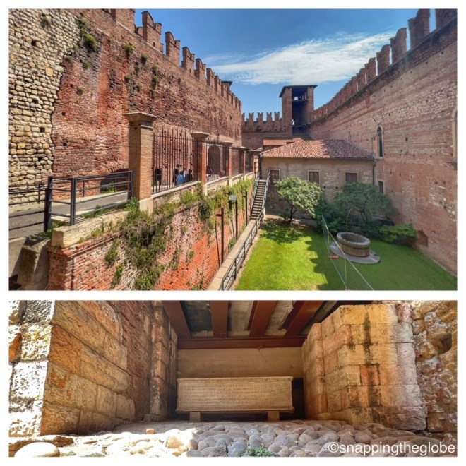
Having planned to see the amphitheater, I decided to take a detour and walk toward the river and the Castelvecchio Museum, since its opening hours were fewer. Making my way across its intimidating drawbridge into the courtyard, I then headed inside to make my way through its major Italian art collections distributed over twenty-nine rooms. Sculpture, paintings, ancient weapons, ceramics, goldsmiths, miniatures and ancient city bells were artfully displayed throughout the castle which dates back to the mid 1300s. While it was built as a residence for the della Scala family, it was mainly used for the military defense of the city and that is evident by its towering walls and battlements.

Castelvecchio Exterior
Castelvecchio Entrance

While I enjoyed my walk through the castle’s interior, what I really wanted to do was investigate the courtyards, the battlements and the clock tower. Climbing up the stairway, I made my way first to the rear of the castle and was rewarded with stunning views of the river and the Scaligero Bridge. It was a beautiful day and being out on the walls was the perfect place to be! Some of the passageways were a bit narrow but easy to navigate and to reach the seven towers. From the front of the castle, the views of the city, the large courtyard, the clock tower and the small courtyard beneath the tower were so stunning that I could have stayed up there all day. Finally, I passed through the adjacent walkway to the bridge and took a quick stroll across so that I could say “I did”.

Scaligero Bridge

If I was going to see everything, however, it was time to move on and I decided to continue my path along the Corso Cavour, which follows the river. A short stroll later, I passed the Arco dei Gavi, a massive, ancient white-marble arch which was was used as a gate in the walls during the Middle Ages. During the Napoleonic rule, French engineers demolished it and its ruins were moved to a square and then to the arena. In 1932, the arch was reconstructed, under Mussolini’s rule, in its current spot next to the Castelvecchio, very near its original location.

Arco dei Gavi

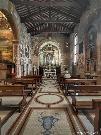
A little further down the road, I happened upon the Basilica di San Lorenzo. As I always make time for a church, I spent a few moments walking through this 12th structure. Built in the Romanesque style on the remains of a 5th or 6th century paleo-Christian building, using some of the original materials, it was interesting to see the two different types of building materials stemming from the different phases of construction…alternating brick and stone which gives the interior a striking pattern of strips in the columns and the walls and apse. Listening in to a tour guide’s spiel, I also learned that a unique feature is the presence of the women’s galleries, still intact and open onto three sides. Though my stop was a quick one, I was glad to see this beautiful church.

Chiesa di San Lorenzo
Chiesa di San Lorenzo Exterior
Chiesa di San Lorenzo

Near the Ponte della Vittoria, I decided to move into the city center as there was more to see in that domain. A few minutes later, I passed under the impressive Porta Borsari, the arched limestone gate, which dates back to the 1st century and served as the main entrance to the city.

Porta Borsari

There were many more churches, including the Church of St. Eufemia; some open, some closed for the afternoon, and as I spied many balconies, I thought of Juliet’s House, which I had planned to visit…whenever I got there! But of course, there was so much to see along the way!

Other churches in Verona

Glancing at my watch, I decided to snatch a few moments at the Church of San Giovanni in Foro. A minor church, it was built on what was the main Roman road. Badly damaged by fire in 1172, while much of Verona was destroyed, its restoration in the early 1900s led to the discovery that Roman walls had been incorporated into the external walls of the church. It was small and dimly lit, but its beautiful mosaics, stone walls and ancient paintings made me glad that I had stumbled upon this gem.

Church of San Giovanni in Foro

Continuing on, I finally made my way to the beautiful Piazza delle Erbe, which was once the center of the city’s political and economic life. There were many market stalls hawking souvenirs and food, but there were lots of statues, fountains and other landmarks to see. More importantly, the square is surrounded by many buildings and monuments that have marked the history of Verona…City Hall, Lamberti Tower, the Houses of Mazzanti, Maffei Palace, the Gardello Tower and the Casa dei Mercanti (Merchant’s House). What I loved most, however, was the ancient fountain (circa 1368) with its roman statue, Madonna Verona, built by Bonino da Campione, which stands proudly in the center of the square and welcomes visitors to investigate its history.

Piazza delle Erbe
Piazza delle Erbe
Piazza delle Erbe
Madonna Verona
Piazza delle Erbe

My goodness…what wasn’t there to see? I love everything about Rome and its “in your face architecture”, but the simplicity of Verona with the minor details that begged you to slow down and savor it was unlike anything I had ever experienced in Italy. Everywhere I laid my eyes, there was stunning construction, architectural details on every building, including balconies upon which other Italian ladies, like the fictional Juliet, may have stood, conversing down to their young paramours.

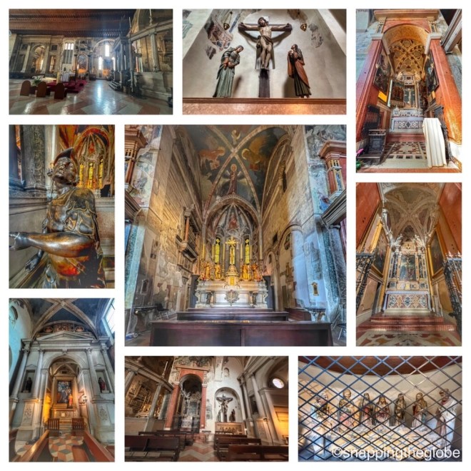
Finding my way to the Scaliger Tombs, I decided that I needed to enter the premises so that I could see these stunning tombs at close range. After paying my entrance fee, I was given a handout to guide me through the small courtyard. Each of the elaborate tombs were unique and some just outright ostentatious. While passerby could get a glimpse through the iron bars of all of the tombs, I thought it much better to see their beauty unobstructed.

Scaliger Tombs

These five funerary monuments celebrate the Scaliger family who ruled in Verona from the 13th to the late 14th century. Located in a wrought-iron fenced enclosure of the church of Santa Maria Antica, these Gothic tombs were constructed for the wealthy members of the noble Scaliger dynasty who ruled as the Lords of Verona; Cangrande I, Mastino II, Cansignorio, Alberto II and Giovanni.

Scaliger Tombs
Scaliger Tombs
Scaliger Tombs

The church was open and I was given a covering for my shoulders as I entered. The modest sanctuary was dimly lit and quiet and it didn’t appear that photographs were appreciated by the woman keeping a sharp eye on the visitors. While I was able to capture a couple undetected, as I was inspecting the 14th century frescoes in the central nave, I took a moment to nod my head in prayer before leaving.

Santa Maria Antica

Finally, next on the list was the famed Juliet’s House, a short walk away. As expected, after walking through the short corridor to the courtyard, I found it extremely crowded with other visitors. Everyone was jockeying for position and waiting for their chance to pose with the bronze statue of Juliet. Noting the balcony above, and those also posing there for photographs, I figured out which door to enter to pay my admission.

Juliet’s House
Juliet’s House

Inside, there were statues paying homage to Shakespeare, another bronze statue of Juliet, period furniture and the bed and Renaissance costumes from Franco Zeffirelli’s 1968 film version of Romeo and Juliet. The wooden floors and artfully decorated ceilings were extremely cozy, although very roomy, depicting the wealth of the Capello family (from which the name Capulet was derived). Eventually, I was able to step out onto the balcony and also pose for a photo, but I was interested to find that even though the house dates back to 13th century, the balcony was only added during the 20th century.

Juliet’s House
Juliet’s House
Juliet’s House

On my way out, I noticed the red mailbox, which collects the letters “to Juliet” from visitors. Remembering the 2010 movie Letters to Juliet, I smiled at the messages visible in the small window in the center, glancing around, wondering where the women who volunteer to answer them were.

Just up the road, I happened upon Porta Leoni, the ancient gate that was built during the Roman Republic and features a double façade and two towers. Adjacent, below the street level are amazing Roman excavations.

Porta Leoni

The afternoon was dwindling away and although I had seen so much during my afternoon visit to Verona, I still wanted to see the amphitheater. Deciding to walk along the river in order to make navigation back to Corso Porta Nuova a little easier, I was stopped in my tracks by an imposing church on the corner.

Chiesa di San Fermo Maggiore.

Chiesa di San Fermo Maggiore

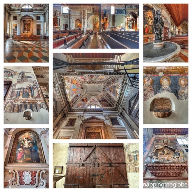
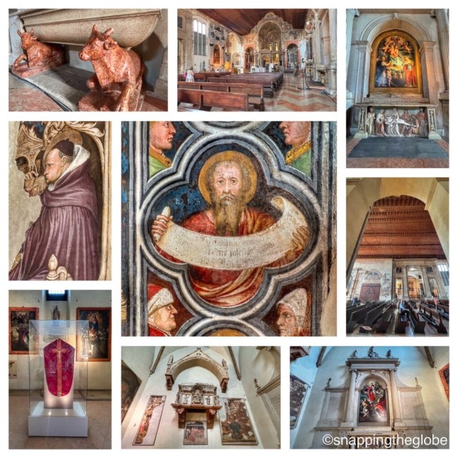
Oh, I was here and I couldn’t resist, so I went in, hoping I had enough time for everything else on my list…namely the amphitheater. The church was still open and I paid my admission, following the handout offered to me, which guided me to both the Upper and Lower churches.

Chiesa di San Fermo Maggiore

Starting with the Lower church, I traversed the ancient staircase to reach the first and oldest cloister of the complex. Here, I marveled at the decorated ribbed vaults and frescoed columns which divided the space. Of particular note was the early 14th century fresco depicting the Virgin seated on a throne with baby Jesus and a 12th century fresco of the Baptism of Jesus. There is a tombstone of jurist Antonio Pelacani, who died in 1327, showing him teaching his students and another of scholar Master Omobono, built in 1330. In the presbytery, there is a wooden crucifix from the 14th century and in the right transept, the stone upon which saints Fermo and Rustico were beheaded.

Lower Church
Lower Church
Lower Church
Lower Church
Lower Church

Back upstairs in the Upper church, I found it to be a massive and towering space. Again, crumbling frescoes decorated the walls and a large wooden door was topped with a fresco of the Crucifixion of Christ. The single nave church contained five apses and of particular interest was the Della Torre altar, from the 18th century, Our Lady’s Chapel (1613), which contains a some significant paintings and the presbytery with its marble altar, created by Schiavi, on which the relics of Saints Fermo and Rustico are kept.

Upper Church
Upper Church
Upper Church
Upper Church
Upper Church
Upper Church
Upper Church

There were many tourists here and there was so much to see in the Upper Church that I spent much more time here than I had anticipated. As I finally exited San Fermo, I regained my routing along the river to head back toward the center of the city where the amphitheater was located. Taking much longer than I had anticipated, along with the heat of the afternoon slowing me down, I realized that I had maybe need to check the train schedule. I was still a ways from the train station and just over an hour away from Venice. As I realized that if I didn’t make the next train, I would be arriving into the Mestre station pretty late and I still needed to keep in mind dinner and the 20 minute walk back to my hotel. Upper ChurchThere were many tourists here and there was so much to see in the Upper Church that I spent much more time here than I had anticipated. As I finally exited San Fermo, I regained my routing along the river to head back toward the center of the city where the amphitheater was located. Taking much longer than I had anticipated, along with the heat of the afternoon slowing me down, I realized that I had maybe need to check the train schedule. I was still a ways from the train station and just over an hour away from Venice. As I realized that if I didn’t make the next train, I would be arriving into the Mestre station pretty late and I still needed to keep in mind dinner and the 20 minute walk back to my hotel.

Sadly, I had saved the amphitheater for last and it was not meant to be.

This time…

With so much to see in Verona, I was impressed with what I had undertaken and experience in a single afternoon. As there is much more enjoy in Verona, I realized that I would definitely return in the near future.

Pulling my KN95 mask from my bag…it was time to make that train.

.For more pictures, check out Facebook, Snapping the Globe and Instagram, @snappingtheglobe.

Castelvecchio Museum

  • https://museodicastelvecchio.comune.verona.it/nqcontent.cfm?a_id=42545
  • Address: Corso Castelvecchio, 2, Verona, Italy
  • Hours: Tuesday to Sunday, 1000 to1800. Last entrance at 1715. Closed Mondays, December 24, January 1.
  • Admission: Adults, €6.00 (+ €.60 online presale), Children (ages 8-14 years), €1.00 (+€.10 online presale). Free admission for residents of 65 years in the Municipality of Verona, persons with disabilities and their companion, children up to 7 years, holders of the VeronaCard.

Arco dei Gavi

Basilica di San Lorenzo

Porta Borsari

  • Address: Corso Porta Borsari, 57A, 37121 Verona VR, Italy
  • Hours: 24 hours, daily
  • Admission: free

Chiesa di San Giovanni in Foro

  • Address: Corso Porta Borsari, 20, 37121 Verona VR, Italy
  • Hours: hours unknown
  • Admission: free

Piazza delle Erbe

Scaliger Tombs

  • Address: Via San M. Antica 1, Verona VR, Italy
  • Hours: unknown
  • Admission: €3 (unverified)

Juliet’s House

Porta Leoni

  • Address: Via Leoni, 37100 Verona VR, Italy
  • Hours: 24 hours daily
  • Admission: free

Chiesa di San Fermo Maggiore

  • https://www.chieseverona.it/it/le-chiese/la-chiesa-di-san-fermo
  • Address: Corte S. Elena, Piazza Duomo 35, 37121, Verona VR, Italy
  • Hours: Monday to Friday, 1100-1800, Saturday, 0930-1800, Sunday, 1300-1800
  • Admission: Single entry €4. Entry to four churches, San Fermo, San Zeno, Cathedral Complex and Santa Anastasia, Basilica of San Zeno, the Cathedral Complex, the Basilica of Santa Anastasia, €8

Look Out Lodi, Here We Come!

©2022 Snapping the Globe, L.L.C. All rights reserved.

Traveling with my friend Cristina is always a treat…she’s one of those few people that I can plan a trip with and expect to see everything that the city has to offer.  She has as much energy as I do and always has an idea for something fun! Together, we are a traveling force to be reckoned with!

Last fall, while working a trip to Milan, we decided that we should take a day trip to a neighboring city. Scouring the map, we looked for cities that were an hour or an hour and a half away and that offered numerous sites and a city center with easy access to the train station.

Stumbling upon a cool little video about the city of Lodi, we decided that this would be our destination.  With only a thirty-minute train ride (a bonus!), a beautiful Piazza and plenty of churches, it looked like there would be plenty to keep us occupied that afternoon.

Heading to Milan’s Centrale Station, we hopped on a train and struck up conversation with a young woman heading toward Bologna. She had been to Lodi and insisted that we would enjoy our excursion, especially since it was one of those no-cloud-in-the-sky warm fall afternoons.

Thirty minutes later, bidding our new friend Arrivederci, we jumped off the train and made our way toward the city center.  Spying some unique architecture and passing through Passeggio Federico I Park and its many monuments, we happened upon the Porta Cremona, a monumental gate which also pays tribute to the fallen of the Great War fought in Lodi, Italy.

Passeggio Federico I Park
Porta Cremona
Porta Cremona

Gazing wistfully at the locked Church of Santa Maria delle Grazie, we continued on knowing that there was much that awaited us only a few blocks away.

Church of Santa Maria delle Grazie

Heading north, we chatted as we passed numerous churches, intriguing alleyways and interesting art and architecture.  Reaching the Napoleon Bonaparte bridge, which spans the Adda river, we stood on its pedestrian walkway gazing out at its muddy waters and the beautiful villas lining its banks.  This bridge played an important role in the Battle of Lodi, during the French Revolutionary War, on May 10, 1796, when the French forces, under Napoleon’s rule, went head-to-head with Austrian forces, led by Karl Philipp Sebottendorf.  While Napoleon was successful in this campaign, it was not a decisive battle, but one that led Napoleon to believe that he was superior to other generals and destined to achieve great things.  A couple blocks from the river we found an interesting statue of Napoleon Bonaparte and a commemorative plaque.

Sights in Lodi
Napoleon Bonaparte bridge, spanning the Adda river

As we continued our walk, we discovered a quaint little courtyard filled with plates decorating the walls. Not sure if it was attached to an artist’s studio, it was fun looking at all the displays.  There were lots of little shops and cafes along the way, many closed for a few hours in the afternoon, but the best one was Gelateria Umberto. Who can resist a couple of scoops of gelato in the afternoon? Not me!

Shops of Lodi
Gelato snack!
San Felippo Neri Church
Archway over Corso Umberto I

Finally, we made it to the Piazza della Vittoria (Victory Square), where the Lodi Cathedral (Duomo) takes the center stage.

Lodi Cathedral

Founded in 1158, the cathedral was completed in two phases, the second, being carried on from 1170 and the façade being completed in 1284. The brick entrance that faces the Piazza is Gothic in style, however, the overall building is Romanesque with a massive bell tower which was left unfinished.

Lodi Cathedral Entrance

As we entered the massive church, the largest in northern Italy and seat of the Bishop of Lodi, we were amazed with how much there was to see within its walls.  Looking down the nave toward the altar, there were two staircases on either side. At the back of the church there were multiple tombs and along each wall, multiple side chapels, the most impressive being a simple niche containing a 15th century, full-size wooden depiction of Christ, his disciples and his blessed mother, Mary.  The church is also connected on the left to the Bishop’s Palace and a court which is the remaining part of a cloister dating back to 1484.

Lodi Cathedral
Lodi Cathedral
Lodi Cathedral
Lodi Cathedral
Lodi Cathedral
Lodi Cathedral
Lodi Cathedral

Up the right-hand staircase, we found the entrance to the crypt, which features a 12th century bas-relief and is the oldest section of the cathedral. In the center of the crypt is an altar dating back to 1856, which houses the remains of Saint Bassianus in a beautifully bedecked silver case. On the left-hand side of the high altar is the altar of Saint Alberto Quadrelli, Bishop of Lodi from 1168 to 1173. 

Bishop’s Palace
Court remains of 15th century cloister

Once our explorations of the cathedral were complete, we headed back into the Piazza, formerly known as the Piazza Maggiore until 1924. The town hall is located here as well as the Vistarini Palace, one of the most beautiful in the city.  Porticos which protect cafe tables from the sun and the elements, line the edges of the square and it is quite colorful and scenic.  It is definitely the heart of the city today where the residents meet for conversation, children play games and the local market is held on Tuesdays and Thursdays in contrast to the fairs, festivals and executions which took place during Medieval times.  As countless bishops have traversed the square over time, it even saw the arrival of Pope John Paul II in 1992.

Piazza della Vittoria
Vistarini Palace

Spying another tall bell tower down one of the streets branching off of the Piazza, we set off on foot attempting to find what lay beneath.  While the church we found was closed, our curiosity led us to an even greater discovery, Il Templo dell’Incoronata.

Chiesa di Santa Maria del Sole
Sights in Lodi
Sights in Lodi
Tempio delle Incoronata

At the end of the 15th century, a brothel with a painting of an image of the Virgin Mary was located in the area known today as via Incoronata.  It is said that in September of 1487, the image of the Virgin Mary wept and called on those present to build a temple dedicated to her on that site…Tempio delle Incoronata or the Temple of the Crowned.

Tempio delle Incoronata Entrance
Tempio delle Incoronata (Rear View)

With the assistance of all citizens of Lodi, the Temple of the City was erected and became one of the most beautiful buildings of Renaissance Lombardy.  Started in 1488 by Giovanni Battagio, a pupil of Bramante, it was completed in 1503, by Lorenzo Maggi, and a portico was added in the late 15th century and the loggia in 1882.  It was through two small doors in the portico that we entered, only because we were being nosy when we saw other tourists exit.  Walking a short distance thru a small, dark hallway, our inquisitiveness was rewarded with one of the most spectacular church interiors that we had both ever laid eyes on. 

Tempio delle Incoronata

The octagonal space was surrounded by arches on the lower level, an altar and an octagonally domed ceiling all highlighted by copious amounts of gilt. Every space not covered in gold was decorated with paintings, most completed by three generations of the Piazza family, who were founding the most prestigious painting school in Italy.  It was almost indescribable!  The only disappointing part was that we were not there on Sunday when the underground space below the monumental sacristy is open to the public.  In this museum space, there are three different rooms housing rare and unique works of sacred art and objects attesting to the importance of the sanctuary.

Tempio delle Incoronata

Giddy with excitement, we headed back out into the city, taking a roundabout route back to the train station. Spotting the Church of San Lorenzo, we ducked inside, perhaps to say a few prayers for our expeditious return to Milan since we were hearing rumblings of a train strike.

Church of San Lorenzo

The city’s oldest church, after the cathedral, was built in the 12th and 13th centuries.  A typical Romanesque-style church, we noticed an image of Saint Lorenzo, above the altar, to whom the church is dedicated. There were several works of art within the church and beautiful architectural details including the apse above the choir with 16th century stucco adornments by Abbondio da Ascona and a fresco of a Resurrected Christ by Callisto Piazza.

Church of San Lorenzo

Glancing at our watches, we noted the time and set off once again, finding ourselves in the Piazza di Castello.  The Visconti Castle spread out before us, including the Torrione di Lodi (Tower of Lodi).  The castle was founded in the 12th century by a member of the Visconti family, the Lord and Dukes of Milan who in the 13th and 14th centuries took possession of and then rebuilt the original fortification. In 1456, Francesco Sforza added a round tower to the northern corner of the castle which eventually (20th century) was converted to a water tower. It has since become a landmark of Lodi greeting those who arrive into the city.  Today, the castle is the seat of the Questura of Lodi, the local office of the Italian Ministry of the Interior. As we studied the exterior of the castle, we realized that we would have liked to have seen more of it, however, it is not open to the public and even if it had been, we had that train to catch!

Piazza di Castello
Visconti Castle and Torrione di Lodi (Tower of Lodi)

Walking quickly, we headed to the train station.  Catching sight of the pink-hued building with its statue dedicated to Amatori Wasken Lodi, the city’s roller hockey team(yes, really…), and the time on the station’s clock, we knew that we had made it in time to get back to Milan for our dinner reservation!

Lodi Train Station and statue dedicated to Amatori Wasken Lodi

While Lodi had not been on our radar as one of the Italian cities we wanted to visit initially, we were so glad that we had found that video prior to our trip which was the inspiration for a wonderful day.  Being so close to Milan was a bonus, but the biggest reward was the multitude of attractions that the city has to offer and getting to share it with my friend, Cristina!

For more pictures check out Facebook, Snapping the Globe and Instagram @snappingtheglobe.com.

Napoleon Bonaparte Bridge (Bridge of Lodi)

  • Address: Via X Maggio, 5, 26900 Lodi, Italy
  • Hours: 24 hours, daily
  • Admission: free

Lodi Cathedral (Duomo of Lodi)

  • http://Diocese.lodi.it
  • Address: Piazza della Vittoria, 4/10 26900 Lodi, Italy
  • Hours: 0730-1200 and 1530-1900, daily
  • Admission: free

Tempio dell’Incoronata

  • http://Incoronata.eu
  • Address: Via Incoronata, 23, 26900 Lodi, Italy
  • Hours: Monday, 0930-1230, Tuesday thru Friday, 0930-1230 and 1530-1800, Saturday and Sunday, 0930-1230 and 1500-1800
  • Mass Schedule: Weekday Mass, Sunday and holidays: 11.30 (visitors must leave the church ten minuts before the function).
  • Admission: free

Museo del Tesoro dell’Incoronata

  • http://Incoronata.eu
  • Address: Via Incoronata, 25 – 26900 Lodi
  • Hours: Sunday, 1500-1800
  • Admission: free
  • Booking is recommended for groups and school visits.

Church of San Lorenzo

  • Address: 9, Piazza S. Lorenzo, 9, 26900 Lodi, Italy
  • Hours: Unknown
  • Admission: free

Castle of Visconti and Torrione di Lodi (Tower of Lodi)

  • Address: 26900, Lodi, Italy
  • Hours: 24 hours daily, viewed from exterior only
  • Admission: not open to the public

Cover Me!

©2020 Snapping the Globe, L.L.C. All rights reserved.

Covered bridges are like lighthouses.

You don’t see many in your everyday life except in certain areas of the country.

While visiting Gettysburg, I learned of the Sachs Covered Bridge. Located not far from the battlefields and President Eisenhower’s home, it was built in 1852 by David Stoner. Spanning one hundred feet over the nearby Marsh Creek, it is considered Pennsylvania’s most historic bridge and was listed in 1980 on the National Register of Historic Places.

So, what makes the bridge so special…besides its beautiful deep crimson hue and tranquil setting? It was used by both Union and Confederate Troops during the Battle of Gettysburg in 1863. Pedestrian traffic is only allowed across the lattice bridge and it is frequented by ghost hunters on a nightly basis. Many ghostly encounters have been witnessed here, so visit at your own risk!

Heading southwest, I encountered the G. Donald McLaughlin Bridge. Also called the Jacks Mountain Bridge, it is the only covered bridge in Adams County that you can still drive through. Located near Fairfield, it was constructed in 1890 using the traditional Burr truss and spans seventy five feet over Tom’s Creek.

It was quite interesting waiting for the traffic light to turn green to control traffic through the bridge. Though I wanted to drive slowly to absorb the experience, it was quite a busy road and I did not want to inconvenience other drivers who probably tire of onlookers. After crossing the bridge to the southern side, I was able to pull off and capture a few photos.

Continuing my journey southward, I crossed into the state of Maryland. Just off of Route 15, I began my search for the three covered bridges that span various tributaries in Frederick County.

Roddy Road Covered Bridge was built in 1856 and lies just north of Thurmont, Maryland. It is the smallest bridge and located adjacent to a children’s park. The bridge is open to car traffic but you can pull over to the left side of the road to take pictures or walk across between the intermittent traffic.

Not far away, I found Loys Station Covered Bridge in Rocky Ridge. If you are looking to make an experience out of visiting this bridge, this is the perfect place! Built in 1880, you can still spot pieces of its original timber as you carefully walk across the bridge, still open to car traffic. On the south side of Owen’s Creek, Loys Station Park is a great place to park, picnic or fish along the banks of the creek. It is a great area to take children to play on the playground equipment while checking out this magnificent piece of architecture.

Finally, with a little bit of driving through the countryside, I located the Utica Road Covered Bridge. Built in 1834, it originally crossed the Monocacy River until 1889 when it was washed away by a storm. Reconstructed, it was moved to its current location across Fishing Creek. Located near Lewistown, it is listed on the National Register of Historic Places.

As the evening came to a close, I scanned my map for of these exceptional landmarks. There were a few more…just much further than daylight would allow!

If you are in the great states of Pennsylvania or Maryland, set out on a unique adventure to see these historic spans that have stood the test of time. Afteral, it is uncertain how much time they have left…

For more pictures, check out Facebook, Snapping the Globe and Instagram, @snappingtheglobe.

Sachs Covered Bridge

  • Address: Waterworks Road, Gettysburg, PA 17325
  • Hours: 24 hours, daily
  • Admission: free
  • Getting There: Sachs Covered Bridge sits in the southwestern corner of Gettysburg National Military Park. The bridge is located at the end of a short dirt road off of Pumping Station Road.

G. Donald McLaughlin Bridge

  • Address: 299-231 Jacks Mountain Road, Fairfield, PA 17320
  • Hours: 24 hours, daily
  • Admission: free
  • Getting There: Jacks Mountain Covered Bridge is located just off of Route 116 on Jacks Mountain Road near Fairfield.

Roddy Road Covered Bridge

  • Address: 14760 Roddy Road Thurmont, MD 21788
  • Hours: 24 hours, daily
  • Admission: free

Loys Station Covered Bridge

  • Address: 13506 Old Frederick Road, Rocky Ridge, MD 21778
  • Hours: 24 hours, daily
  • Admission: free

Utica Covered Bridge

  • Address: 720 Utica Road, Thurmont, MD 21788
  • Hours: 24 hours, daily
  • Admission: free

The Suicide Bridge

©2020 Snapping the Globe, L.L.C. All rights reserved.

Covered bridges are a source of fascination for many and there are a few located in the southern Pennsylvania and northern Maryland areas.  One, in particular, is located in Gettysburg near the battlefields and was used by both Union and Confederate soldiers. 

In addition to my explorations of the Gettysburg battlefields, I had anticipated side trips into the countryside to each of these. 

After leaving the Eisenhower home, however, I passed by an old trestle bridge.  There were a few people standing on the bridge, which was closed to traffic, and I thought that it might be a good photo opportunity.

Parking and exiting my car, I made my way through the overgrowth on the road’s shoulder onto the bridge.  A plaque on the left, identified it as the John Eisenhower bridge and one on the right, displayed details of its builders, Gilbert & Smith, and the date of its completion, 1886.

The bridge was in a state of decomposition and it’s position being infringed upon by creeping vines and weeds.  Nevertheless, it was nice to observe the rushing, clear water beneath and listen to the birds chirping in the trees.

Only staying a few minutes, I hopped back on the road to complete my battlefield tour. 

It was a bit later that evening, that I learned from my waiter, that the John Eisenhower bridge has been dubbed the “Suicide Bridge”.  Now, there are many haunted sites throughout Gettysburg, some I knew about, however, I was curious about this one.

A little digging left me without any further knowledge about the bridge’s history but the idea that this is a paranormal hot spot, thought to be frequented by ghosts from those that have ended their lives here by hanging. Many ghost tours take you to this location, their guests hoping to see a ghostly apparition or experience energy from the other side. 

I can tell you that had I known this earlier, I might have been a little apprehensive about spending time in this location.  To be fair, however, it was broad daylight and didn’t seem so creepy.

Now, nighttime is another thing and I hear that many people head there during the dead of night, hoping to capture some sort of eerie phenomenon!

Not me! 

If you are interested in one paranormal investigation team’s visit, check out their video on You Tube, https://www.youtube.com/watch?v=8_PgA7RN–Q&t=836s

Check out Facebook, Snapping the Globe and Instagram, @snappingtheglobe.

John Eisenhower Bridge

  • Address: 185 Waterworks Rd, Gettysburg, PA 17325
  • Hours: 24 hours, daily
  • Admission: free


Thrown From the Bridge

©2020 Snapping the Globe, L.L.C. All rights reserved.

There is a statue on Prague’s Charles Bridge of Saint Johannes van Nepomuk (St. John of Nepomuk) that I have walked past many times and often rubbed the plaque at the bottom for good luck.

Everyone needs a little luck and I wouldn’t want the bridge to crumble beneath my feet, plunging me to my death into the Vltava River, right?

It is widely known that Saint Johannes van Nepomuk, a priest, was drowned in the Vltava River on the orders of Wenceslaus IV, King of the Romans and King of Bohemia. He is considered the first martyr and a protector from floods and drowning.

What I was not aware was that there are other statues of Saint Johannes van Nepomuk throughout the world including,

  • Monument on Cathedral Island, at the Church of the Holy Cross, Wroclaw, Poland 
  • St. John of Nepomuk Statue in Buchach, Ukraine
  • Statue of St. John of Nepomuk in Divina, Slovakia
  • Saint Nepomuk on the Schwarzen Bridge in Loningen, Germany
  • Statue of St. John of Nepomuk in churchyard of the cathedral, Passau, Germany
  • Statue of St. John of Nepomuk in churchyard of the cathedral, Passau, Germany
  • Roadside figure of St. John of Nepomuk, Buchach, Ukraine
  • Statue on bridge of St. John Nepomuk, Wurzburg, Bavaria, Germany

When I had planned our route through Bruges, I had noticed a monument marked on my Google map as a point of interest on the Wollestraat Bridge. We had stopped to take a couple of pictures of the statue, dodging a tour guide and their group, but continued on our journey that day. It wasn’t until later when someone asked if we had seen the famous statue on the bridge that I realized it was an important landmark in Bruges.

This statue of the Saint was designed by Flemish sculptor Pieter Pepers in 1767 and appears, like most others, with a halo of five stars, which commemorate the stars that hovered over the Vltava River on the night of his murder and which are said to symbolize the five letters of the Latin word “tacet” which means silent. He is adorned in priestly robes and carries a large crucifix to which he has set his gaze upon.

What we learned was that the original statue was replaced in 1811.

Why?

It was thrown in to the Dyver Canal in 1795!

Seems that Saint Nepomuk can’t stay off of bridges or out of the river!

For more pictures, check out Facebook, Snapping the Globe and Instagram, @snappingtheglobe.

Saint Johannes of Nepomuk Statue

  • Address: Dijver, 8000 Brugge, Belgium
  • Hours: 24 hours, daily
  • Admission: free

Biking the Bridge

© 2019 Snapping the Globe, L.L.C. All rights reserved.

What do you think of when you think of San Francisco?

I think of the Golden Gate Bridge.

The iconic suspension bridge that spans the mile-wide strait that connects San Francisco Bay and the Pacific Ocean, also connects the city of San Francisco to Marin County on the northern tip of the San Francisco Peninsula. It has been described as one of the most beautiful bridges in the world and is certainly one of the most photographed.

A photograph is what I wanted most, but then I heard that you could walk across the bridge and I knew that that was something I was going to do.

After a quick lunch at Pier 39, we had decided that we were going to walk to the Golden Gate Bridge. Looking down the coast, however, we realized that it was really far.

So…how were we going to get there?

Uber? Bus? Trolley?

Stepping out onto the boardwalk, we found our answer.

Bicycle.

Blazing Saddles Bike Rental was offering bikes for rent and advertising, “Bike the Bridge”. Yes, this was the way to go!

Paying our rental fees, we hopped on one of the bikes that the staff pulled out for us and headed down the boardwalk that parallels The Embarcadero.

An easy ride during the warm afternoon, we stopped every so often to photograph and enjoy some of the landmarks that dot the coastline…the Ferry Arch, Fisherman’s Wharf, the Maritime Museum, the pier at Aquatic Park Cove, Ghiradelli Square. Continuing on, we made our way past Fort Mason, the Marina District Lighthouse, Palace of the Fine Arts and Crissy Field, where we now had unobstructed views of the the stately bridge.

Wishing we had thought to bring some water with us, we were able to get some just before heading onto the bridge at the Golden Gate Bridge Welcome Center. Resting for a few minutes, we noticed how many people were engaged by their tour guides before heading on to the bridge.

We peddled on to the bridge, artfully dodging tourists attempting to walk four and five abreast, not realizing they were sharing the walkway with two-wheeled vehicles. Happy that we had bike bells, we rang them occasionally, passing the hundreds of people making their way across the 1.7 mile span.

It was so exciting to look up at this engineering marvel while we rode along, stopping occasionally for the requisite selfie.

Finally, making it to the H. Dana Bower Rest Area, we were able to get our land legs back and enjoy the stunning views of the bridge. Our plan had been to continue on from here along the pathway to Sausalito, enjoy a drink and take the ferry back to San Francisco, however, taking a look at the time, we were concerned about the ferry schedule and if we had sufficient time to make it back to return our bikes. Instead, we decided to head back across the bridge, the way we came.

Not realizing that the bike traffic was now directed to the other side of the bridge, we rode along leisurely until we were almost back to the other side. Here (oops!), a cop stopped us and informed us that we had to hop off of our bikes and walk them for the rest of the way on the bridge.

Slowing our progress, we finally reached the mainland and hopped back on. Continuing on our way, we realized that we were making good time so we slowed our pace, enjoying the views, even stopping to walk around the Palace of Fine Arts…a lovely setting on a beautiful day!

Taking one last look at the Golden Gate Bridge, we realized just how far we had traveled and what we had accomplished.

Yes, that is definitely what I envision when I think of San Francisco!

Next time, however, we simply need to leave earlier so we can check out Sausalito!

Check out Facebook, Snapping the Globe and Instagram, @snappingtheglobe for more pictures.

The Golden Gate Bridge

  • http://www.goldengatebridge.org/\
  • Address: Golden Gate Bridge, San Francisco, CA
  • Pedestrian Hours: Pedestrians, including persons with disabilities using mobility devises such as wheelchairs, are allowed access ONLY on the East Sidewalk (side facing San Francisco). The hours vary seasonally as follows…Pacific Standard Time,East Sidewalk hours are 5 am to 6:30 pm. Automatically-controlled gates close at 6:30 pm and reopen at 5 am. Daylight Savings Time,East Sidewalk hours are 5 am to 9 pm. Automatically-controlled gates close at 9 pm and reopen at 5 am.
  • Bicycle Hours: Sidewalk hours during Pacific Standard Time (first Sunday in November to second Sunday in March. Weekdays, 5:00 am to 3:30 pm: EAST sidewalk. 3:30 pm to 6:30 pm: WEST sidewalk 6:30 pm to 5:00 am: EAST sidewalk, via remotely-controlled security gates located at both ends of the EAST sidewalk.
    Cyclists press the “buzzer” located near the closed security gate. After security staff locates the cyclist on a security camera, the gate is opened remotely. Cyclists repeat this procedure to get through the security gate at the other end of the sidewalk. Weekends and Holidays, 5:00 am to 6:30 pm: WEST sidewalk 6:30 pm to 5:00 am: EAST sidewalk, via remotely-controlled security gates located at both ends of the EAST sidewalk. Cyclists press the “buzzer” located near the closed security gate. After security staff locates the cyclist on a security camera, the gate is opened remotely. Cyclists repeat this procedure to get through the security gate at the other end of the sidewalk. Sidewalk hours during Daylight Saving Time (second Sunday in March to first Sunday in November. Weekdays, 5:00 am to 3:30 pm: EAST sidewalk. 3:30 pm to 9:00 pm: WEST sidewalk 09:00 pm to 5:00 am: EAST sidewalk, via remotely-controlled security gates located at both ends of the EAST sidewalk. Weekends and Holidays, 5:00 am to 9:00 pm: WEST sidewalk 9:00 pm to 5:00 am: EAST sidewalk, via remotely-controlled security gates located at both ends of the EAST sidewalk.
  • Admission: free
  • Bicycle Access on EAST and WEST Sidewalks. Cyclists have toll-free access to the Bridge’s sidewalks 24-hours a day. Cyclists MUST yield to pedestrians and use caution in the areas of the towers as there is limited space to maneuver and sight distances are constrained. Electric bicycles may be ridden on the sidewalks; however they must be pedaled and may NOT be used under power while on the sidewalk.

Palace of Fine Arts

The Old Covered Bridge

© 2019 Snapping the Globe, L.L.C. All rights reserved.

Why did the pedestrian cross the river?

To check out the beautiful covered bridge.

Okay, so that’s not how the old joke goes, but when one sees a beautiful covered bridge, one must absolutely take a walk to the other side!

Having decided to take some side trips from Milan lately, I ventured out to the town of Pavia on the advice of a friend. Marking a few items of interest on my map, the first one I wanted to see was the Ponte Coperto (the Covered Bridge), also called the Ponte Vecchio (the Old Bridge).

The structure is a brick and stone arch bridge which crosses the Ticino River and replaces the previous medieval bridge, dating from 1354 (with an even older Roman one preceding it). When the previous bridge was damaged during the war in 1945, repair was considered until the structure partially collapsed a couple of years later.

The new bridge’s design was based on the previous bridge and was begun in 1949, incorporating one difference and one similarity. The previous bridge contained seven arches and the current one contains only five, however, like its predecessor, it contains a chapel in the center.

The Ponte Coperto connects the suburbs, the traditional place of washerwomen, gravel quarrymen and fisherman, to the city’s center and there were many pedestrians crossing the bridge as I made my way to the other side.

Peeking inside the chapel at the altar, devoted to St. Giovanni Nepomuceno, patron of drowned men, I also paid particular attention to the vaulted wood ceiling above. In the center of the bridge, I stopped to examine the remains of the ancient Roman bridge ruins which sit in the rushing water of the Ticino.

So what did I do after I made my way to the other side?

I went back!

There’s lots more to see in Pavia!

For more pictures, check out Facebook, Snapping the Globe and Instagram, @snappingtheglobe.

Ponte Coperto

  • http://www.comune.pv.it/site/home.html
  • Address: 27100 Pavia, Province of Pavia, Italy
  • Hours: daily, 24 hours
  • Admission: free
  • Getting There: About a 12-15 minute walk from the Pavia train station

Bridging the Gap

© 2019 Snapping the Globe, L.L.C. All rights reserved.

While walking in the La Latina neighborhood of Madrid, a glance at my map offered up an icon illustrating a point of interest.

Viaducto de Segovia.

Since I was headed in that general direction, I thought I would check it out.

I won’t lie. I saw the word viaduct and the picture in my head was of something I would see in Rome. Old…brick…arches. And don’t forget the boatloads of tourists milling about taking pictures.

What I found instead was more of a modern structure…a bridge spanning Segovia Street, 25 meters below, thus giving it its name.

Segovia Street lies in the basin formed by the old San Pedro Creek which was one of the most important routes of entry from Segovia into Madrid many centuries ago. At the time, Bailén Street ended at the edge of the ravine and pedestrians were forced to make the steep descent and ascent from Segovia Street to reach the area of the Royal Palace of Madrid.

When the Royal Court was established in 1561, King Philip began to promote the expansion of the city. He visualized extending Bailén Street across the ravine to allow easy travel to other parts of the city and country.

Although the architect of the Royal Palace, Juan Bautista Sacchetti, conceived a plan to build a span, lack of funding put the proposal on the back-burner until 1874, when a structure made of wood and iron was completed. This structure remained until 1932 when architects Ferrero, Aracil and Aldaz created plans for a concrete structure. Taking only two years to complete, this bridge sustained damage during the Spanish Civil War in the Seige of Madrid, but was repaired in 1942.

Though a plan was put into place in the later part of the 1970’s, to demolish the bridge, a decision was finally made to restore it instead. Today’s construction is a result of that restoration, which allowed for the increase of its height and span and more importantly, the increasing traffic loads and capacity.

Today, the Viaducto de Segovia is not a main tourist attraction, but one that tourists merely “happen” upon due to its proximity to the Cathedral de la Almudena and the Royal Palace of Madrid. It is quite famous, not only for having been featured in many literary works and Spanish cinema, but for a reason most do not like to talk about. Until 1998, it was the site of countless suicides, thus being dubbed “the suicide bridge”. Recognizing the ease of access pedestrians had over the low edges, authorities finally erected transparent screens to prevent further attempts.

If you find yourself in the area, take a walk across the bridge on the pedestrian lanes for a beautiful view of the Casa de Campo and the lake. When heading south, take the stairs on the left hand side to venture down to Segovia Street for a more intimate view of the bridge’s structure.

It truly is an architectural marvel and a piece of Madrid’s developmental history.

For more pictures, check out Facebook, Snapping the Globe and Instagram, @snappingtheglobe.

Viaducto de Segovia

  • Address: Calle de Bailén, 12, 28005 Madrid, Spain
  • Hours: 24 hours, daily
  • Admission: free